"An understanding of relief is central to the study of landscapes and landforms. 'Relief' is the term geographers use to describe the shape of the land, including the height and steepness. The main techniques used by cartographers to show relief on topographic maps are spot heights, contour lines and patterns, and layer colouring and landform shading."

Topographic Map
Elements of a Topographic Map:
- Spot Height: Shown on the map as a black dot with the height written next to it. Gives the exact height above sea level of a particular location or feature.
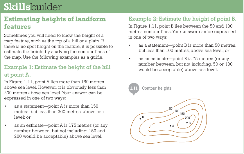
- Contour Lines: Joins points of equal height above sea level. Every point along the line has the same value.
- Contour Pattern: The spacing of the contours (lines) on the map shows the steepness of slopes. Close together means that area is steep, widely spaced lines indicate that area is very flat. The space also represents the shape of the slope; when the spacing reading from high to low decreases, the slope is convex (curved like a circle). When the spacing lines reading from high to low increases, the slope is concave (curves in like a cave).
- Layer Colouring: Involves colouring the area between selected contours in different colours. When it is used in combination with spot heights, and sometimes landform shading, layer contouring can tell you a good deal about the shape of the land.
- Landform Shading: Colours can be used on maps, with colours darkening as elevation (height) increases (image below).
- Aspect: Refers to the direction that a slope faces. The aspect of a particular slope can be determined by examining the height and pattern of contour lines.
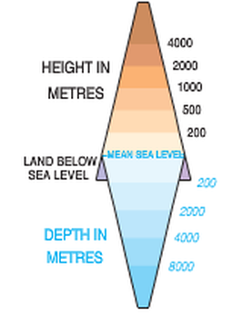
An example of Landform Shading. Pearson Page 64
For your information:
Pearson Page 11
Complete these questions in your work book:
- Define the term 'relief'
- What are the elements of relief and briefly explain what they are used for
- What does the spacing between contour lines tell us about relief?
